

Maps
![]() Discount prices on some maps are available to WWTA Members. If you are a member, please login. Join to enjoy full member benefits.
Discount prices on some maps are available to WWTA Members. If you are a member, please login. Join to enjoy full member benefits.
 SeaTrails Marine Maps
Waterproof paper
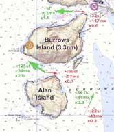
Sea Trails covers the entire Puget Sound area. For a full list of maps and to purchase, go to WWTA's SeaTrails Marine Maps page.
SeaTrails is donating 1% of all sales from this map series to Washington Water Trails Association to help preserve access to Washington's waters for future generations.
Lake Union & Portage Bay:
History in the Heart of Seattle
Water Resistant paper
Take a self-guided tour of Lake Union's historic features, learn native place-names, read first-hand accounts of life on the Lake, watch for wildlife, and find a place to launch your hand-carried boat. The History in the Heart of Seattle map will orient you to a wealth of opportunities to recreate & explore! Pick yours up at
the Center for Wooden Boats, MOHAI, Seattle paddle shops, or WWTA office.
For a $1.00 handling charge, WWTA will mail you one first class. Order
online.

Coastal Waters Recreation - Marine Maps of Puget Sound
Marine Recreation Maps are an excellent resource for trip planning. The maps highlight points of interest, wildlife viewing areas, picnic and camping sites, as well as boat launches and beach access. These maps are for reference only, and should not be used for navigation.